โฉนดที่ดิน
Reading a Thai land title deed
Six numbers that look alike, three units of area in one measure, and a drawing in the middle of a form.
โฉนดที่ดิน is the strongest form of Thai land document. It names a parcel, states its area, and records who holds it, and the land office issues and endorses it.
Finding the parcel again is what the identifiers are for. เลขที่โฉนด, ระวาง, เลขที่ดิน and หน้าสำรวจ together point at one piece of ground, which is why a due diligence check reads all of them and never just the first.
The specimen#
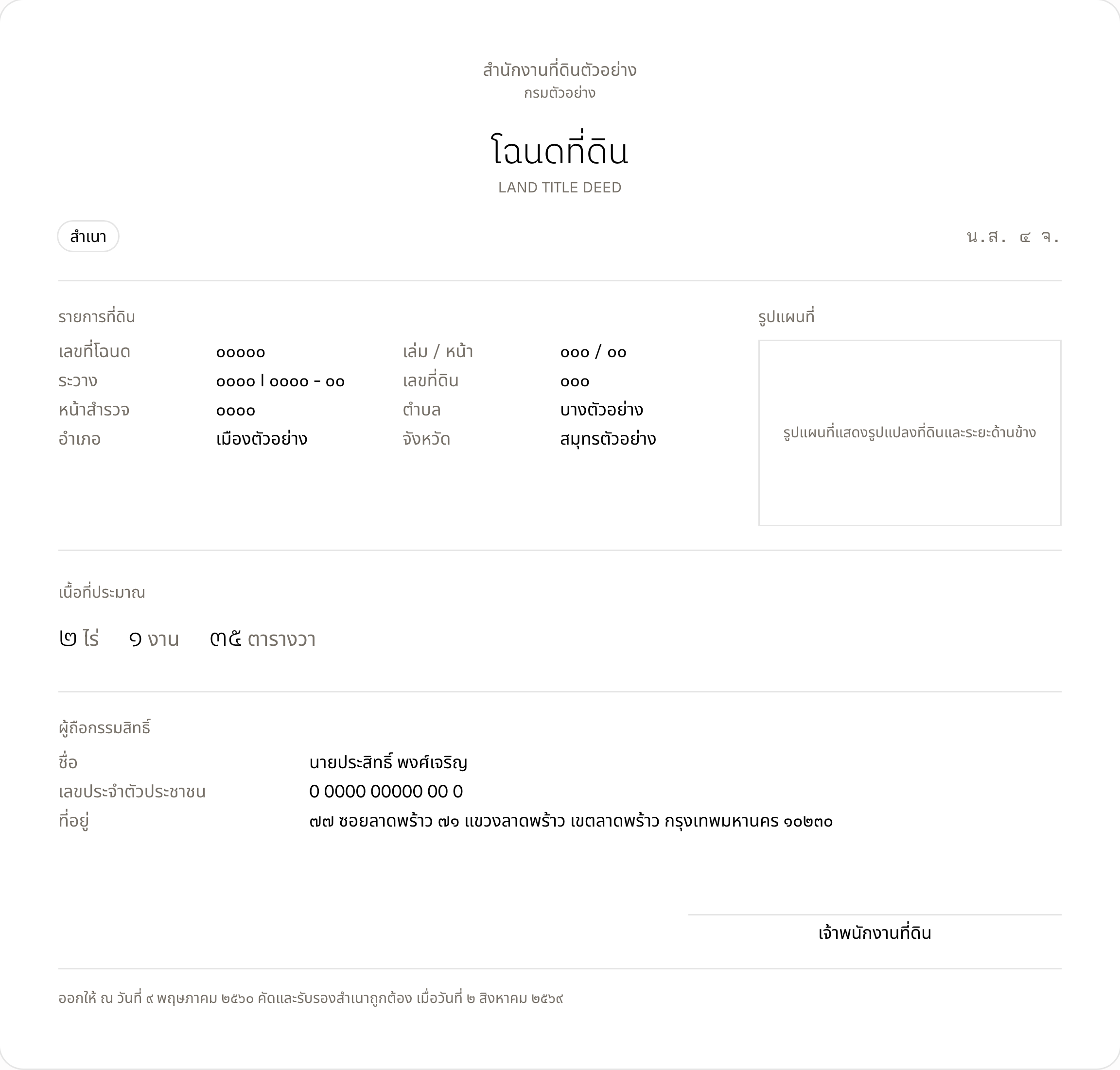
This sheet is typeset from the document's real field list. Every name and figure on it is invented, and none of it comes from anyone's paperwork.
สำนักงานที่ดินตัวอย่าง
กรมตัวอย่าง
โฉนดที่ดิน
LAND TITLE DEED
รายการที่ดิน
- เลขที่โฉนด
- ๐๐๐๐๐
- เล่ม / หน้า
- ๐๐๐ / ๐๐
- ระวาง
- ๐๐๐๐ I ๐๐๐๐ - ๐๐
- เลขที่ดิน
- ๐๐๐
- หน้าสำรวจ
- ๐๐๐๐
- ตำบล
- บางตัวอย่าง
- อำเภอ
- เมืองตัวอย่าง
- จังหวัด
- สมุทรตัวอย่าง
รูปแผนที่
เนื้อที่ประมาณ
๒ ไร่๑ งาน๓๕ ตารางวา
ผู้ถือกรรมสิทธิ์
- ชื่อ
- นายประสิทธิ์ พงศ์เจริญ
- เลขประจำตัวประชาชน
- 0 0000 00000 00 0
- ที่อยู่
- ๗๗ ซอยลาดพร้าว ๗๑ แขวงลาดพร้าว เขตลาดพร้าว กรุงเทพมหานคร ๑๐๒๓๐
เจ้าพนักงานที่ดิน
ออกให้ ณ วันที่ ๙ พฤษภาคม ๒๕๖๐ คัดและรับรองสำเนาถูกต้อง เมื่อวันที่ ๒ สิงหาคม ๒๕๖๙
What the model read#
paxa-ocr-lite-v1 · captured Aug 31, 2026 · unedited
The Markdown it returned
สำนักงานที่ดินตัวอย่าง
กรมตัวอย่าง

# โฉนดที่ดิน
LAND TITLE DEED

สำเนา

น.ส. ๔ จ.

รายการที่ดิน

เลขที่โฉนด ๐๐๐๐๐
ระวาง ๐๐๐๐ | ๐๐๐๐ - ๐๐
หน้าสำรวจ ๐๐๐๐
อำเภอ เมืองตัวอย่าง

เล่ม / หน้า ๐๐๐ / ๐๐
เลขที่ดิน ๐๐๐
ตำบล บางตัวอย่าง
จังหวัด สมุทรตัวอย่าง

รูปแผนที่

*[Figure: รูปแผนที่แสดงรูปแปลงที่ดินและระยะด้านข้าง]*

เนื้อที่ประมาณ

๒ ไร่ ๑ งาน ๓๕ ตารางวา

ผู้ถือกรรมสิทธิ์
ชื่อ นายประสิทธิ์ พงศ์เจริญ
เลขประจำตัวประชาชน ๐ ๐๐๐๐ ๐๐๐๐๐ ๐๐ ๐
ที่อยู่ ๗๗ ซอยลาดพร้าว ๗๑ แขวงลาดพร้าว เขตลาดพร้าว กรุงเทพมหานคร ๑๐๒๓๐

เจ้าพนักงานที่ดิน

ออกให้ ณ วันที่ ๙ พฤษภาคม ๒๕๖๐ คัดและรับรองสำเนาถูกต้อง เมื่อวันที่ ๒ สิงหาคม ๒๕๖๙
The structured blocks, typeset back into a page
- paragraph
สำนักงานที่ดินตัวอย่าง
- paragraph
กรมตัวอย่าง
- headingL1
โฉนดที่ดิน
- paragraph
LAND TITLE DEED
- paragraph
สำเนา
- paragraph
น.ส. ๔ จ.
- table
The table the model reconstructed รายการที่ดิน รูปแผนที่ เลขที่โฉนด ๐๐๐๐๐ เล่ม / หน้า ๐๐๐ / ๐๐ รูปแผนที่แสดงรูปแปลงที่ดินและระยะด้านข้าง ระวาง ๐๐๐๐ | ๐๐๐๐ - ๐๐ เลขที่ดิน ๐๐๐ หน้าสำรวจ ๐๐๐๐ ตำบล บางตัวอย่าง อำเภอ เมืองตัวอย่าง จังหวัด สมุทรตัวอย่าง - paragraph
เนื้อที่ประมาณ
- paragraph
๒ ไร่ ๑ งาน ๓๕ ตารางวา
- paragraph
ผู้ถือกรรมสิทธิ์
- paragraph
ชื่อ นายประสิทธิ์ พงศ์เจริญ
- paragraph
เลขประจำตัวประชาชน ๐ ๐๐๐๐ ๐๐๐๐๐ ๐๐ ๐
- paragraph
ที่อยู่ ๗๗ ซอยลาดพร้าว ๗๑ แขวงลาดพร้าว เขตลาดพร้าว กรุงเทพมหานคร ๑๐๒๓๐
- paragraph
เจ้าพนักงานที่ดิน
- paragraph
ออกให้ ณ วันที่ ๙ พฤษภาคม ๒๕๖๐ คัดและรับรองสำเนาถูกต้อง เมื่อวันที่ ๒ สิงหาคม ๒๕๖๙
What is on this document#
Common commercial shape
- เลขที่โฉนด
- The deed number.
- เล่ม / หน้า
- The volume and page it is recorded in.
- ระวาง
- The survey sheet the parcel sits on.
- เลขที่ดิน
- The parcel number within that sheet.
- หน้าสำรวจ
- The survey page reference.
- ตำบล อำเภอ จังหวัด
- Sub-district, district, and province.
- เนื้อที่
- Area as three figures: ไร่, งาน, and ตารางวา.
- ชื่อผู้ถือกรรมสิทธิ์
- The holder, with an identity number.
- รูปแผนที่
- The survey figure, drawn beside the fields.
- วันที่ออก
- Issue date and the endorsing officer.
The land office prescribes this form. What varies between deeds is the number of endorsements on the reverse, which a single-page reading does not see.
Why this one is hard to read#
- Six identifiers that look the same
- Deed number, volume, page, survey sheet, parcel number and survey page are all bare numerals in adjacent labelled slots. Swap any two and the reading points at different ground.
- Area is three numbers in one measure
- ไร่, งาน and ตารางวา are one quantity written as three figures, and they do not decimalise. A reading that returns them separately with their units is the only one that can be converted safely.
- A figure sits inside the form
- The survey drawing is a picture in the middle of a field block. It has to come back as a figure in its position, without the reader trying to read the lines as text.
From blocks to fields#
The parcel identifiers come back as labelled values in reading order, and the survey figure comes back as a figure block where it sits. Keeping the labels attached is what matters here, because six numerals with their labels stripped are six numerals nobody can use.
- Rate
- 6.5 credits per page
- Per request
- 50 pages, 10 MB, PDF, PNG, JPEG, WEBP
- Free credits
- 100 credits, about 15 pages
Questions#
- Does a reading prove ownership?
- No. It returns what is printed on the sheet you sent. Title is what the land office's own register says. A document check is one input to that, and it stands in for nothing.
- What about the endorsements on the back?
- The reverse is another page. Send both, up to 50 pages a request, and each comes back as its own entry.
- Is the survey drawing interpreted?
- It comes back as a figure block in its position, and the reading makes no attempt to turn boundary lines into coordinates or measurements.
Send it your own documents.
New accounts start with 100 free credits, enough for about 15 pages. Try it on a real file in the playground.